The route of the 2012 Olympic marathon runs straight past my front door! How exciting is that?
But maybe not for much longer. There are mutterings, and rumours, and posturings which suggest that the marathon won't be coming my way after all. It won't pass through the East End, and it won't finish at the Olympic Stadium. Instead the Tower Hamlets arm will be amputated to allow the race to finish on the Mall instead. Which would be a bloody disgrace.
This decision isn't yet certain. Indeed Olympic chiefs haven't yet made any official announcement whatsoever. So I'll hold back from describing the organising committee as "a bunch of brand-obsessed fuckwits who don't give a toss about local communities", at least until the news is confirmed.
The new route, allegedly, runs three times round a circuit of Central London, both starting and finishing on the Mall. It'll pass such renowned London landmarks as Tower Bridge, St Paul's, Big Ben and Buckingham Palace, which should look lovely on TV and attract millions of extra tourists to visit our fair city. But it'll no longer pass Whitechapel Market, Mile End and the Bow Flyover because, by implication, they're shitholes unworthy of prime global airtime.
I am, to say the least, pissed off by this.
I've been very excited about the east-facing route of the London marathon ever since it was first announced. And I'm not the only one.
London 2012 Chairman, Sebastian Coe, said London's famous sights and settings will help to make the London 2012 Marathon a unique and unforgettable Olympic experience for all involved. "We wanted to design a course that will create lasting memories and moments for the runners, spectators, television audiences and the Olympic Movement; a course that will inspire a new generation of athletes and runners," said Coe, a double Olympic Gold medallist. (15 April 2005)The previous route, which made Seb all weak at the knees, wasn't much different to the revised route being touted around today. It started at Tower Bridge, then ran three identical loops down to Westminster and back, passing almost every iconic London landmark an international TV broadcaster could have desired [map]. Apart from the precise starting point, this concept of "three times round central London" hasn't changed. What has changed is that in the old version when the runners reached Aldgate for the third time they carried on, and ran up the A11 (aka HS2012, aka BCS2) to reach the Olympic Stadium. Because Olympic marathons always end at the Olympic Stadium. Even if that means, as in Athens in 2004, running along 'boring' peripheral roads lined with flats, shops and garages. London 2012 want to break the mould by ending in front of the Queen's house instead, and bollocks to tradition and to the East End.
One especially feeble excuse being wheeled out is that this more compact course "enables spectators lining the route to watch the runners pass by several times." Pah, you devious fact-twisting bastards, the old route did that too. In fact the new route allows fewer people to watch the marathon than was previously planned, because the triple-loop still exists but nobody in East London gets to see the race at all. The Nu-Marathon looks like being a sanitised circuit race designed to minimise road closures, and all to avoid the Olympic Route Network clogging up. We can't have sponsors' limousines getting stuck in traffic, can we, because they're the priority.
And let's get this in perspective. A marathon is 26.2 miles long. The road from Aldgate to the Olympic Park in Stratford is 3.3 miles long. This means that TV broadcasters have kicked up a fuss about a mere 12½% of the marathon route. World class athletes should be able to run this distance in about 15 minutes. A couple of strategically placed commercial breaks should cover that, if TV bosses are really so paranoid about showing what they perceive to be uninterrupted kebab shops and council estates. To be honest, I think audiences might appreciate a few miles of something different after 1¾ hours of thrice-repeated landmarks.
All is not yet lost. A London 2012 spokeswoman said: "We have not yet confirmed all the details of the marathon route, we are in the process of finalising all the details and we hope to announce an approved route shortly." But if the final route castrates the East End, then half a million nearby residents are going to feel wholly cheated when marathon day comes round. And "a bunch of brand-obsessed fuckwits who don't give a toss about local communities" is going to be the mildest of my thoughts.
If London is really so ashamed of its East End, perhaps it shouldn't have built the Olympic Stadium there.
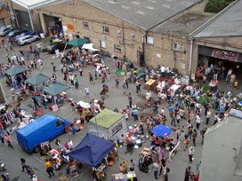 Where's the epicentre of East London's creative community? Brick Lane? More a tourist trap than an arts hub. Shoreditch? No longer as cool as it once thought it was. Try
 The following day much of the line had degraded. The glue wasn't designed to be permanent, and passing footfall had
 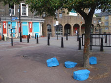 But the students had one last trick to encourage audience interaction. They'd brought along several simple 'added extras', all painted the same shade of vibrant blue, and dumped them liberally all over the square. A
  •
• 

 Every time a planning decision is made that you disagree with, it's likely that you missed the public consultation which would have enabled you to disagree in advance. Equally, even the very best planning applications contain minor niggles that make them less than perfect, but which you could easily have pointed out if only anyone had asked. So it's been good of

 The blue shaded areas are the sections of each platform from which a 'next train' indicator can be seen. Maybe not easily, and maybe requiring a step to one side and a shuffle, but visible all the same. Good news, that's pretty much the entire length of the westbound District line platform, as well as most of the eastern half of the station (the end furthest away from the station entrance). But there's a long-term problem with the (yellow) 'Way out' signs, because they're positioned right up close to the four 'next train' indicators in the centre of each platform. They have to be there, it's Health and Safety, because everybody needs to know how to get out. But they act as an opaque shield to the destination information immediately behind, which means that the 'next train' can't be viewed from any of the areas I've shaded red. Bloody useless, but nothing new.
 If you've never lived around here, you probably don't know
 It's a bloody massive lock. After my
  Now stop me if I'm wrong, but an average of one big barge per fortnight is a pretty unimpressive strike rate. The whole idea of funding the lock in the first place was to enable the transfer of waterborne cargo during the peak construction window, and that doesn't appear to be happening yet. To give you some idea of the scale of the problem, Three Mills Lock was