Here are ten E3-related things I'd be interested in reading about...
• The Green Bridge - is it dying?
• Mile End station - seriously, which cretin thought this was an improvement?
• Which is E3's most heritage-tastic street?
• Are Tesco ever going to build that controversial store on Roman Road?
• Is Jongleurs worth a visit? Is it even still open?
• Gangs of E3 - is there a secret subculture?
• That new set of traffic lights outside the police station, useless or what?
• Whatever happened to the London Gas Museum?
• Tower Hamlets Cemetery Park - it's nice, innit?
• The new St Andrew's development - who'd buy a box in the sky?
...although I bet your list would be more interesting (and probably more relevant).
Tuesday, 28 September 2010
Monday, 27 September 2010
Launch
I thought I'd start a hyperlocal blog of my own. I mean, why not? I've called it eethree (because ethree and e-three were already taken), and here it is. Don't get excited, there's nothing on here you haven't read on my main blog already. I've uploaded all my E3-related posts from the last couple of years to create a brief backstory, and now all that's missing is the new stuff. Maybe you'd help me write it.
I don't have time to maintain two blogs, not properly, so I'd be delighted if certain local folk could help me out with this new one. Let me know, and I'll add friendly literate authors to my eethree permissions list. Only news and comment from the E3 postcode will be permitted. That includes Mile End, Bow and Bromley-by-Bow, even Three Mills and Fish Island, but not Victoria Park or the Olympic Park. Please let's have nothing extreme, nor rampantly advertorial, nor anything applicable to Tower Hamlets as a whole. I reserve the right to moderate what gets churned out, or even to delete the entire project if it doesn't work. But let's hope eethree takes off. HyperEastEndlocality, it's the future you know.
I don't have time to maintain two blogs, not properly, so I'd be delighted if certain local folk could help me out with this new one. Let me know, and I'll add friendly literate authors to my eethree permissions list. Only news and comment from the E3 postcode will be permitted. That includes Mile End, Bow and Bromley-by-Bow, even Three Mills and Fish Island, but not Victoria Park or the Olympic Park. Please let's have nothing extreme, nor rampantly advertorial, nor anything applicable to Tower Hamlets as a whole. I reserve the right to moderate what gets churned out, or even to delete the entire project if it doesn't work. But let's hope eethree takes off. HyperEastEndlocality, it's the future you know.
Thursday, 23 September 2010
Snickers
WARNING: This post contains rude words and swearing. And justifiably so, I think.
The route of the 2012 Olympic marathon runs straight past my front door! How exciting is that?
But maybe not for much longer. There are mutterings, and rumours, and posturings which suggest that the marathon won't be coming my way after all. It won't pass through the East End, and it won't finish at the Olympic Stadium. Instead the Tower Hamlets arm will be amputated to allow the race to finish on the Mall instead. Which would be a bloody disgrace.
This decision isn't yet certain. Indeed Olympic chiefs haven't yet made any official announcement whatsoever. So I'll hold back from describing the organising committee as "a bunch of brand-obsessed fuckwits who don't give a toss about local communities", at least until the news is confirmed.
The new route, allegedly, runs three times round a circuit of Central London, both starting and finishing on the Mall. It'll pass such renowned London landmarks as Tower Bridge, St Paul's, Big Ben and Buckingham Palace, which should look lovely on TV and attract millions of extra tourists to visit our fair city. But it'll no longer pass Whitechapel Market, Mile End and the Bow Flyover because, by implication, they're shitholes unworthy of prime global airtime.
I am, to say the least, pissed off by this.
I've been very excited about the east-facing route of the London marathon ever since it was first announced. And I'm not the only one.
One especially feeble excuse being wheeled out is that this more compact course "enables spectators lining the route to watch the runners pass by several times." Pah, you devious fact-twisting bastards, the old route did that too. In fact the new route allows fewer people to watch the marathon than was previously planned, because the triple-loop still exists but nobody in East London gets to see the race at all. The Nu-Marathon looks like being a sanitised circuit race designed to minimise road closures, and all to avoid the Olympic Route Network clogging up. We can't have sponsors' limousines getting stuck in traffic, can we, because they're the priority.
And let's get this in perspective. A marathon is 26.2 miles long. The road from Aldgate to the Olympic Park in Stratford is 3.3 miles long. This means that TV broadcasters have kicked up a fuss about a mere 12½% of the marathon route. World class athletes should be able to run this distance in about 15 minutes. A couple of strategically placed commercial breaks should cover that, if TV bosses are really so paranoid about showing what they perceive to be uninterrupted kebab shops and council estates. To be honest, I think audiences might appreciate a few miles of something different after 1¾ hours of thrice-repeated landmarks.
All is not yet lost. A London 2012 spokeswoman said: "We have not yet confirmed all the details of the marathon route, we are in the process of finalising all the details and we hope to announce an approved route shortly." But if the final route castrates the East End, then half a million nearby residents are going to feel wholly cheated when marathon day comes round. And "a bunch of brand-obsessed fuckwits who don't give a toss about local communities" is going to be the mildest of my thoughts.
If London is really so ashamed of its East End, perhaps it shouldn't have built the Olympic Stadium there.
The route of the 2012 Olympic marathon runs straight past my front door! How exciting is that?
But maybe not for much longer. There are mutterings, and rumours, and posturings which suggest that the marathon won't be coming my way after all. It won't pass through the East End, and it won't finish at the Olympic Stadium. Instead the Tower Hamlets arm will be amputated to allow the race to finish on the Mall instead. Which would be a bloody disgrace.
This decision isn't yet certain. Indeed Olympic chiefs haven't yet made any official announcement whatsoever. So I'll hold back from describing the organising committee as "a bunch of brand-obsessed fuckwits who don't give a toss about local communities", at least until the news is confirmed.
The new route, allegedly, runs three times round a circuit of Central London, both starting and finishing on the Mall. It'll pass such renowned London landmarks as Tower Bridge, St Paul's, Big Ben and Buckingham Palace, which should look lovely on TV and attract millions of extra tourists to visit our fair city. But it'll no longer pass Whitechapel Market, Mile End and the Bow Flyover because, by implication, they're shitholes unworthy of prime global airtime.
I am, to say the least, pissed off by this.
I've been very excited about the east-facing route of the London marathon ever since it was first announced. And I'm not the only one.
London 2012 Chairman, Sebastian Coe, said London's famous sights and settings will help to make the London 2012 Marathon a unique and unforgettable Olympic experience for all involved. "We wanted to design a course that will create lasting memories and moments for the runners, spectators, television audiences and the Olympic Movement; a course that will inspire a new generation of athletes and runners," said Coe, a double Olympic Gold medallist. (15 April 2005)The previous route, which made Seb all weak at the knees, wasn't much different to the revised route being touted around today. It started at Tower Bridge, then ran three identical loops down to Westminster and back, passing almost every iconic London landmark an international TV broadcaster could have desired [map]. Apart from the precise starting point, this concept of "three times round central London" hasn't changed. What has changed is that in the old version when the runners reached Aldgate for the third time they carried on, and ran up the A11 (aka HS2012, aka BCS2) to reach the Olympic Stadium. Because Olympic marathons always end at the Olympic Stadium. Even if that means, as in Athens in 2004, running along 'boring' peripheral roads lined with flats, shops and garages. London 2012 want to break the mould by ending in front of the Queen's house instead, and bollocks to tradition and to the East End.
One especially feeble excuse being wheeled out is that this more compact course "enables spectators lining the route to watch the runners pass by several times." Pah, you devious fact-twisting bastards, the old route did that too. In fact the new route allows fewer people to watch the marathon than was previously planned, because the triple-loop still exists but nobody in East London gets to see the race at all. The Nu-Marathon looks like being a sanitised circuit race designed to minimise road closures, and all to avoid the Olympic Route Network clogging up. We can't have sponsors' limousines getting stuck in traffic, can we, because they're the priority.
And let's get this in perspective. A marathon is 26.2 miles long. The road from Aldgate to the Olympic Park in Stratford is 3.3 miles long. This means that TV broadcasters have kicked up a fuss about a mere 12½% of the marathon route. World class athletes should be able to run this distance in about 15 minutes. A couple of strategically placed commercial breaks should cover that, if TV bosses are really so paranoid about showing what they perceive to be uninterrupted kebab shops and council estates. To be honest, I think audiences might appreciate a few miles of something different after 1¾ hours of thrice-repeated landmarks.
All is not yet lost. A London 2012 spokeswoman said: "We have not yet confirmed all the details of the marathon route, we are in the process of finalising all the details and we hope to announce an approved route shortly." But if the final route castrates the East End, then half a million nearby residents are going to feel wholly cheated when marathon day comes round. And "a bunch of brand-obsessed fuckwits who don't give a toss about local communities" is going to be the mildest of my thoughts.
If London is really so ashamed of its East End, perhaps it shouldn't have built the Olympic Stadium there.
Sunday, 1 August 2010
Hackney Wicked
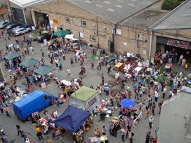 Where's the epicentre of East London's creative community? Brick Lane? More a tourist trap than an arts hub. Shoreditch? No longer as cool as it once thought it was. Try Hackney Wick. Its winding streets and graffiti-ed warehouses are home to more contemporary arty folk than you might expect, and this weekend they're throwing their doors open as part of the Hackney Wicked Festival. A damned impressive amount of cultural stuff is on show. More than 600 artists' studios are open (go on, any other part of London, beat that), and you're free to wander around and have a look. Just-painted canvases, quirky sculptures, mucky workdesks with nibbles on, that sort of thing. Some of the old buildings are more interesting than the art (sorry), including the opportunity to walk up three or four floors for a nice view over the Olympic Park. One gallery has bands playing on the roof, plus sofas for slouching in, plus astroturf and beer; another is hosting a fake church fete complete with tea and cakes. There are two main foci, one around Hackney Wick station and the other on Fish Island. In the former, it was great to see the derelict Lord Napier pub opened up, and Queen's Yard given over to a market with live music and food [homemade chocolate brownie from endearingly amateur bakers, tick]. In the latter, minor road closures gave rise to impromptu street parties, again with music, crafts and drink much in evidence [plastic beaker of Pimms poured by lady wearing lampshade, tick]. Forman's salmon smokery was open, with access to a roof terrace and the chance to look round their permanent top floor art gallery [smoked salmon bagel cooked by chef in the street, yum]. The whole event was packed with hipsters and beardykids, average age about 30 I'd have said, which made me feel a bit like I wasn't target audience. But I spent far longer looking round than I expected, and got to explore several non-pristine buildings I'd only ever walked past never dreaming I'd get inside. If you go today be warned that Hackney Wick station is closed, and that the event's website frequently collapses due to excessive demand. But never mind, just turn up and collect the excellent programme/map, and you won't miss a thing. Watch out in particular for the Coracle Regatta on the Lea (2-6pm), and a demonstration by the Hackney Wick Cold War Re-enactment Society (noon-3pm), and a closing procession to "Burn the Wicker Man" (ends 9:30pm). And pray that nobody ever sanitises and commercialises this end of town, because it's wicked as it is.
Friday, 2 July 2010
LFA 2010
The London Festival of Architecture hit my bit of town last weekend. Up and down High Street 2012, from Aldgate to Stratford, a series of building-worthy events and installations to celebrate the East End's architectural creativity. And one of those events was really close to home, in the unlikely locale of Stroudley Walk, E3.
If you don't live around here, all you need to know is that Stroudley Walk is post-war-grim. A windswept piazza lined by bottom-of-the-heap retail units. A boarded-up pub in the shadow of a squat tower block, and a chippie I'm not convinced sells cod any more. An echoing void with space enough for a complete market, where only one single stall-trader sets up shop. It's nowhere to linger, unless you've got some cheap alcohol and the entire day to spare. Socially speaking, Stroudley Walk's an architectural disaster.
 Enter the University of Innsbruck. As part of the The International Student Architecture Festival, they asked architecture students to create some challenging artistic installations up and down High Street 2012. An innovative slatted staircase in Whitechapel, for one, and some guerilla gardening (in rubber gloves) along the Lea towpath north of the Bow Flyover [photo] [photo]. Stroudley Walk got Walk The Line, which was essentially the opportunity to slap a bright blue line across the pavement and see what happened. Simple and cheap, but would any of the locals react?
The blue line went down a week ago. The students painted glue all the way along Bromley High Street, then painstakingly walked along and stuck a thick strip of blue tape over the top. At the junction with Bow Road they draped a roll of blue cloth along the railings of the gents conveniences, and tied the top end to Mr Gladstone's right hand. All in all surprisingly effective [photo]. And then they went back to their lodgings for the evening.
 The following day much of the line had degraded. The glue wasn't designed to be permanent, and passing footfall had dislodged several sections and left others flapping. The blue cloth had been moved so it didn't impede passing pushchairs heading to the pelican crossing. And in Stroudley Walk itself, the entire blue line had been ripped up and thrown into the square's recycling bins. The culprit could have been pesky kids, but I prefer to believe that some well-meaning cleaner assumed the line was vandalism not art, and dutifully removed the lot.
Over the weekend Mr Gladstone's ribbon was unceremoniously chopped, leaving no line to walk, only a short strip of fabric dangling in mid-air. But the students had a better idea for a more durable line elsewhere. They used blue paint this time, and progressed along Stroudley Walk putting out branches to various features along the way. A 'postcard' branch to the post office, a 'market' branch to the fruit & veg stall, that sort of thing, adding a little complexity to the project. But the local populace were unmoved. They walked straight through the area as normal, especially the adults, even the kids, I suspect because nobody quite understood what was going on.
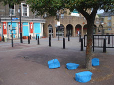 But the students had one last trick to encourage audience interaction. They'd brought along several simple 'added extras', all painted the same shade of vibrant blue, and dumped them liberally all over the square. A blue bookcase, with free books to take away. Four blue deckchairs under a blue umbrella. A blue dining table, plus seating. A blue noughts and crosses board with blue counters. Two billowing blue curtains with a gap inbetween labelled 'theater'. A square of blue chipboard (with a hole in it) dropped over a bollard to create a makeshift table. And lots of stumpy wooden trunks, painted blue, clustered to create areas of temporary seating. Success.
Local residents paused, and stopped, and lingered. A bunch of teenagers sat around on the blue tree trunks and chatted. The lady from the dry cleaners rested on some blue wood while she had a fag. Merry lager-drinkers settled at the blue table to lap up beer and sunshine. The theatre remained empty, from what I saw, because that was probably culturally over-adventurous for round here. But it was great to see the area temporarily transformed into "a place accommodating social interaction." It's taken a bunch of Austrian students to point out that Stroudley Walk lacks a beating heart, and that communal renaissance could be kickstarted by something as simple as a few cheap benches and a bit of imagination.
• Loopzilla's Walk The Line Flickr photoset
• Plans to revitalise Stroudley Walk (i.e. build more homes and a new tower block)
• The London Festival of Architecture concludes this weekend (at Bankside Urban Forest)
If you don't live around here, all you need to know is that Stroudley Walk is post-war-grim. A windswept piazza lined by bottom-of-the-heap retail units. A boarded-up pub in the shadow of a squat tower block, and a chippie I'm not convinced sells cod any more. An echoing void with space enough for a complete market, where only one single stall-trader sets up shop. It's nowhere to linger, unless you've got some cheap alcohol and the entire day to spare. Socially speaking, Stroudley Walk's an architectural disaster.
Enter the University of Innsbruck. As part of the The International Student Architecture Festival, they asked architecture students to create some challenging artistic installations up and down High Street 2012. An innovative slatted staircase in Whitechapel, for one, and some guerilla gardening (in rubber gloves) along the Lea towpath north of the Bow Flyover [photo] [photo]. Stroudley Walk got Walk The Line, which was essentially the opportunity to slap a bright blue line across the pavement and see what happened. Simple and cheap, but would any of the locals react?The blue line went down a week ago. The students painted glue all the way along Bromley High Street, then painstakingly walked along and stuck a thick strip of blue tape over the top. At the junction with Bow Road they draped a roll of blue cloth along the railings of the gents conveniences, and tied the top end to Mr Gladstone's right hand. All in all surprisingly effective [photo]. And then they went back to their lodgings for the evening.
The following day much of the line had degraded. The glue wasn't designed to be permanent, and passing footfall had dislodged several sections and left others flapping. The blue cloth had been moved so it didn't impede passing pushchairs heading to the pelican crossing. And in Stroudley Walk itself, the entire blue line had been ripped up and thrown into the square's recycling bins. The culprit could have been pesky kids, but I prefer to believe that some well-meaning cleaner assumed the line was vandalism not art, and dutifully removed the lot.Over the weekend Mr Gladstone's ribbon was unceremoniously chopped, leaving no line to walk, only a short strip of fabric dangling in mid-air. But the students had a better idea for a more durable line elsewhere. They used blue paint this time, and progressed along Stroudley Walk putting out branches to various features along the way. A 'postcard' branch to the post office, a 'market' branch to the fruit & veg stall, that sort of thing, adding a little complexity to the project. But the local populace were unmoved. They walked straight through the area as normal, especially the adults, even the kids, I suspect because nobody quite understood what was going on.
But the students had one last trick to encourage audience interaction. They'd brought along several simple 'added extras', all painted the same shade of vibrant blue, and dumped them liberally all over the square. A blue bookcase, with free books to take away. Four blue deckchairs under a blue umbrella. A blue dining table, plus seating. A blue noughts and crosses board with blue counters. Two billowing blue curtains with a gap inbetween labelled 'theater'. A square of blue chipboard (with a hole in it) dropped over a bollard to create a makeshift table. And lots of stumpy wooden trunks, painted blue, clustered to create areas of temporary seating. Success.Local residents paused, and stopped, and lingered. A bunch of teenagers sat around on the blue tree trunks and chatted. The lady from the dry cleaners rested on some blue wood while she had a fag. Merry lager-drinkers settled at the blue table to lap up beer and sunshine. The theatre remained empty, from what I saw, because that was probably culturally over-adventurous for round here. But it was great to see the area temporarily transformed into "a place accommodating social interaction." It's taken a bunch of Austrian students to point out that Stroudley Walk lacks a beating heart, and that communal renaissance could be kickstarted by something as simple as a few cheap benches and a bit of imagination.
• Loopzilla's Walk The Line Flickr photoset
• Plans to revitalise Stroudley Walk (i.e. build more homes and a new tower block)
• The London Festival of Architecture concludes this weekend (at Bankside Urban Forest)
Saturday, 24 April 2010
Local news for local people
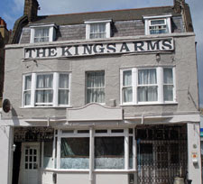 • Kings Arms update: I wrote last summer that the Kings Arms pub in Bow Road appeared to have closed down. The building then went very quiet until earlier this year when builders arrived and started doing the place up. I realised the worst - no more pub - when I peered in through the windows and saw partition walls and a staircase where the bar used to be. This week the new owners have even painted over the characterful "Kings Arms" lettering on the front of the building and replaced this with a wonky ill-judged aberration whose letters are already peeling off. The full name of the new business is only revealed in a tiny amateur sign in the window, inkjet-printed from a single sheet of A4 paper. This has been chopped into strips and stuck with tape not quite horizontally to the glass, and mutely announces the arrival of the "Kings Arms Guest House". As rebranding goes, this is woefully inept. The 2-star guest house has yet to open, but already has a web presence written by incompetents: "Kings Arms Guest House is a newly refurbished bughet accomodation that has excellent connectivity due to its prime location that suites to the Olympic Site officials working at Stratford, Banking & Business sector community of Canary Warf & Excel Centre and the tourists travelling to Central London visiting places." Another pub bites the dust, stripped and gutted to meet the 21st century business paradigm. Only the landlord of the Bow Bells opposite might raise a glass to that.
• 488 bus update: Good news for Hackney/Bow residents who use the 488 bus to get home from Tesco. TfL have tweaked the 488's southbound destination, truncating the route by two stops so that it now terminates outside Tesco in Hancock Road. This means that northbound buses now start from Tesco, allowing elderly shoppers to hop on here rather than having to lug their bags on a long trek under a dual carriageway. This greatly improves on TfL's previous (whispered) advice to pensioners to stay on the bus to Twelvetrees Crescent, wait while the driver stopped off for a fag, and then continue back up to Roman Road. It's only taken 2 years to get back the looped service lost when the S2 was withdrawn in 2008. Except this isn't quite the perfect solution. The southbound 488 now terminates one stop short of Bromley-by-Bow station, which means that a direct connection between bus and tube has been lost. Meanwhile each northbound bus stops at Bromley-by-Bow station twice, once on each side of the dual carriageway, which is pointless overkill. It seems that TfL have prioritised access to Tesco over access to their own tube station. Why am I not surprised?
• Bromley-by-Bow Tesco update: Planning permission is now being sought for the development of an utterly ginormous Tesco just to the south of the existing superstore. A revised application is up on the Tower Hamlets website, and there's very little time to object. It's hard to see what's changed since the last lot of plans, which were damningly described as "incoherent" and "piecemeal" by government advisory body CABE. In particular the Tesco store still gets the prime spot by the river, while the residential blocks and multi-storey hotel are fated to stare out across the noisy smelly A12. They also want to divert northbound buses so that these serve the new store rather than the existing community. It's easy to see what benefits Tesco get from the redevelopment, but I fear that their priorities are about to ride roughshod over an ideal solution for local residents. A planning decision like this only gets made once, but we'll all have to live with the consequences for decades.

Saturday, 5 December 2009
Lack of Standards
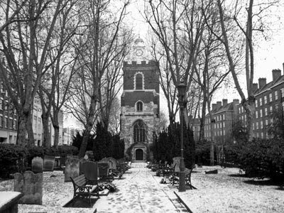
Two months on from the Evening Standard's giveaway rebirth, how is its distribution network doing? You may remember that free copies were originally available only outside central London stations and in scattered suburban supermarkets. By last month a few more independent shops and newsagents had got involved. And now? I've taken yet another look at the Evening Standard's newly-updated distribution map to find out. And I've summarised my findings in this handy graphic.
 Bloody hell, what happened there?!
The Evening Standard appears to have increased its number of distribution points in certain parts of London, but made a planned withdrawal from others. A huge triangle bounded by Enfield, Clapham and Richmond is now full of newspapers. Kilburn's on the up, Chiswick's on the up, Muswell Hill's on the up and (of course) Chelsea's on the up. A number of smaller newsagents have been added to the network here, which is great. There's also been some infill in parts of northwest London (hurrah for Harrow) and even down south (Forbuoys in Dulwich, rah rah rah). We have winners.
But there are also some very surprising losers. In Romford, where there used to be two distribution points, there are now zero. Walthamstow now has nothing, Sidcup has nothing, Purley has nothing, Uxbridge has nothing. In particular, the Evening Standard has almost completely given up on East London. The only distribution points east of the River Lea are to be found in Stratford and at London City Airport. Live anywhere else out east and the Standard has abandoned you. This means it's now impossible to pick up a Standard anywhere in the boroughs of Waltham Forest, Redbridge, Barking & Dagenham and Havering. Add in no-go zones in Bexley and Sutton south of the river, and the London Evening Standard is no longer a pan-London paper. Which sucks.
I did wonder whether this disappearance might be a mapping error, so I attempted to check. There's a freephone number in the Standard you're supposed to be able to ring during office hours to find out where to get a paper, so I rang it. A few rings and I was diverted to an answerphone message suggesting I try the map on the website. Alternatively I could leave my name and number and they'd ring me back "within two working days". I rang again later and got the same ludicrous response. Stuff that. So I tried some fieldwork of my own, and my worst fears were confirmed.
Last month the only place to obtain an Evening Standard in the E3 postcode was at my local Tesco. But the ES map no longer marks my local Tesco, so I trooped round with my shopping basket to investigate further. Hmmm, no sign of any Standards where they used to be, between the potatoes and the magazine rack. I enquired at the helpdesk to find out where they'd gone. "Oh no," said the lady behind the counter. "We used to have them for a few weeks, but not any more. They took them to the station instead."
So I crossed the A12 and went to Bromley-by-Bow station instead. This ought to be a very sensible location to give out Standards, because there's a steady flow of customers plus a newsagent's kiosk from which a pile of free papers could easily be distributed. The kiosk even has "Evening Standard" plastered across the front of it - no doubt a leftover from a bygone age when local people actually mattered. "Oh no," said the old bloke in the kiosk. "We haven't had any of those for months." He looked mildly annoyed by this, most likely because he has now nothing else to trade in the evenings other than drinks and snacks.
So yes, it is now impossible to obtain a copy of the Evening Standard anywhere in Bow, E3. Indeed you won't find a copy anywhere within about a mile and a half of Bow Church station. But head across town to Turnham Green station, also on the zone 2/3 boundary, and there are as many as 14 distributors within a similar radius. It appears that the Evening Standard has made a very selective retreat from the suburbs, and that it no longer gives a toss about East London. I fear that East Londoners won't miss it.
Bloody hell, what happened there?!The Evening Standard appears to have increased its number of distribution points in certain parts of London, but made a planned withdrawal from others. A huge triangle bounded by Enfield, Clapham and Richmond is now full of newspapers. Kilburn's on the up, Chiswick's on the up, Muswell Hill's on the up and (of course) Chelsea's on the up. A number of smaller newsagents have been added to the network here, which is great. There's also been some infill in parts of northwest London (hurrah for Harrow) and even down south (Forbuoys in Dulwich, rah rah rah). We have winners.
But there are also some very surprising losers. In Romford, where there used to be two distribution points, there are now zero. Walthamstow now has nothing, Sidcup has nothing, Purley has nothing, Uxbridge has nothing. In particular, the Evening Standard has almost completely given up on East London. The only distribution points east of the River Lea are to be found in Stratford and at London City Airport. Live anywhere else out east and the Standard has abandoned you. This means it's now impossible to pick up a Standard anywhere in the boroughs of Waltham Forest, Redbridge, Barking & Dagenham and Havering. Add in no-go zones in Bexley and Sutton south of the river, and the London Evening Standard is no longer a pan-London paper. Which sucks.
I did wonder whether this disappearance might be a mapping error, so I attempted to check. There's a freephone number in the Standard you're supposed to be able to ring during office hours to find out where to get a paper, so I rang it. A few rings and I was diverted to an answerphone message suggesting I try the map on the website. Alternatively I could leave my name and number and they'd ring me back "within two working days". I rang again later and got the same ludicrous response. Stuff that. So I tried some fieldwork of my own, and my worst fears were confirmed.
Last month the only place to obtain an Evening Standard in the E3 postcode was at my local Tesco. But the ES map no longer marks my local Tesco, so I trooped round with my shopping basket to investigate further. Hmmm, no sign of any Standards where they used to be, between the potatoes and the magazine rack. I enquired at the helpdesk to find out where they'd gone. "Oh no," said the lady behind the counter. "We used to have them for a few weeks, but not any more. They took them to the station instead."
So I crossed the A12 and went to Bromley-by-Bow station instead. This ought to be a very sensible location to give out Standards, because there's a steady flow of customers plus a newsagent's kiosk from which a pile of free papers could easily be distributed. The kiosk even has "Evening Standard" plastered across the front of it - no doubt a leftover from a bygone age when local people actually mattered. "Oh no," said the old bloke in the kiosk. "We haven't had any of those for months." He looked mildly annoyed by this, most likely because he has now nothing else to trade in the evenings other than drinks and snacks.
So yes, it is now impossible to obtain a copy of the Evening Standard anywhere in Bow, E3. Indeed you won't find a copy anywhere within about a mile and a half of Bow Church station. But head across town to Turnham Green station, also on the zone 2/3 boundary, and there are as many as 14 distributors within a similar radius. It appears that the Evening Standard has made a very selective retreat from the suburbs, and that it no longer gives a toss about East London. I fear that East Londoners won't miss it.
Wednesday, 18 November 2009
TescBow
 Every time a planning decision is made that you disagree with, it's likely that you missed the public consultation which would have enabled you to disagree in advance. Equally, even the very best planning applications contain minor niggles that make them less than perfect, but which you could easily have pointed out if only anyone had asked. So it's been good of Tesco to ask my local community what they think of proposals to double the size of their superstore in Bromley-by-Bow, and of plans to stick a library, hotel and housing nextdoor. Sadly only a handful of the local community have so far taken up the opportunity.
There was a "Community Forum" event at Kingsley Hall last night, hosted by the Tower Hamlets planning team, at which a suited Tesco threesome were given a public opportunity to put forward their proposals. Slightly revised from those they presented in September, and which I outlined here, but this time a teensy-bit more firmed up. And another chance to screen their very impressive computer generated "fly-through", so that we could all gulp and go "blimey, really, gosh" and "oh look, they can't spell pedestrain crossing". The area facing redevelopment is to the eastern side of the A12 close to Bromley-by-Bow tube station, including the current Tesco and the industrial land between that and the railway. Everything here could look very different before the Olympics, and even more different a couple of years later.
It was illuminating to hear Tesco's representatives belittling the current Bromley-by-Bow store as badly-stocked and underperforming. Serves us all right for doing our shopping there for several years, I guess. But the new Tesco Extra, if built, will be a whopper. Almost Beckton-sized, we were told, with all the increased traffic that might bring. It'll have a "bespoke sustainable roof design" which'll let in plenty of light, and an underground car park with 480 spaces. That's only 30 spaces more than exist outside the store today, so let's hope that a larger proportion of the new shoppers arrive by public transport.
Plans are afoot for much more than just a megastore. 18 adjacent retail units for a start, hopefully selling goods that can't be undercut by Tesco nextdoor, and perfect for residents who can't be bothered to go to the new Stratford Westfield up the road. There'll be a 10 storey hotel, probably of the Travelodge/Premier Inn style, with another 10 storeys of apartments piled high on top. I can't imagine wanting to stay here myself, not unless it's a particular few weeks in mid-2012, but a cut-price room beside a Zone 2 tube station should have potent backpacker appeal. There'll be a medium-sized Idea Store, for which all credit to Tower Hamlets council for squeezing a souped-up library out of a multinational. And a gym! I cannot imagine a £500-a-year gym being popular in Bromley-by-Bow today... but the proposed future is, I suspect, rather yuppier.
Many attendees were interested in transport-related issues. Would there be any new bus services? No, and they were sorry TfL couldn't be persuaded to reinstate the S2. Would the subway under the A12 from the tube station be upgraded and enlarged and better lit? Yes, and about time too. How would cars approach the new district centre? Via a new "all movements junction" on the dual carriageway, which when installed would become the only traffic lights between Poplar and the Redbridge roundabout. Last night's attendees were split between delight at a non-subterranean pedestrian crossing of the A12, and concern that speeding Blackwall-bound traffic might not really want to stop.
And what of timing? If all goes to plan and the appropriate land is snapped up, construction will begin around this time next year. The new MegaTesco will then be ready to open in March 2012, just in time to sell to grab-and-go sandwiches to visiting Olympic tourists. The Idea Store would also open at this time, and the 18 neighbourhood shops, and hopefully the renovated subway. But as for the 25%-affordable housing on the old Tesco site, plus the new hotel and the new park and the new school, expect these no earlier than 2014. Drivers on the A12 need fear no new pedestrian crossing until 2014 either, because there are rules in place banning any kind of major road upgrade before the Olympics.
None of this is yet a fait accompli. Tesco are putting in their planning application at the end of the month and then Tower Hamlets will go through all the appropriate official consultation stages into the New Year. There'll then be full opportunity for local residents to inspect and interact with the proposals, including via an as-yet-unregistered website called tescoinbromleybybow.co.uk (dangerous things, as-yet-unregistered websites). Up until now the consultation has been Tesco's own, farmed out to a private liaison company who've been busy gathering feedback. I was impressed to hear that "1000 expressions of support" had been received, but less than reassured when the consultants admitted that a huge proportion of these had been obtained by approaching shoppers in the existing store. I trust that the E3 community will give Tesco's plans rather more diligent scrutiny in the months ahead, but I bet that 99% of them won't even notice until the whole megaplex is eventually underway.
Thursday, 12 November 2009
Installed by cretins
Last year I spent an entire week blogging about 'next train' indicators, and how they're installed by cretins in locations where passengers can't actualy read them. After the week was over I enjoyed some lengthy email communications with one of TfL's Press Officers, who empathised with my thoughts and assured me (in some detail) that things were slowly getting better. One particular paragraph in her reply stood out, which was this:
 Let me illustrate this with an up-to-the-minute example of 'next train' indicator cretinousness, which is happening as we speak at Mile End station. The platforms at Mile End have been a complete dump for the last couple of years because they were mid-strip-out when Metronet collapsed and the tube upgrade programme ran out of money. Recently, finally, the station's modernisation has kicked off again, which appears to involve the construction of a suspended ceiling across the top of Mile End's cavernous platforms. It's unnervingly low, indeed so low that the ceiling is in some places lower than the top line of the existing 'next train' indicators. Which means that passengers arriving down the stairs onto the westbound Central line platform can no longer see where the next train is heading. The second train's fine, but not the first, because a metal bar at new-ceiling-height now blocks the view [enlarged photo]. Cretins, I tell you, absolute bloody cretins.
Mile End is already seriously sub-optimal for the viewing of 'next train' indicators. Its rows of prettily-tiled pillars don't help, because they tend to block either the left hand end of the board (destination) or the right hand end of the board (minutes). But the real problem has been that there aren't enough 'next train' indicators, and they aren't in the right place. Let me sketch you a pretty diagram of Mile End station to show you what I mean.

Mile End's two eastbound platforms form an island across the top, and its two westbound platforms form an island across the bottom. Trains run along the white strips - the Central line very-top and very-bottom, and the District/H&C through the middle. The stairs down from the ticket hall are at one end of each platform, whereas the exit stairs are located much more centrally. There are four 'Way out' signs, shown in yellow, and six 'next train' boards, shown in blue. The bottom left 'next train' board is one-sided only, facing west. And all the green squares represent pillars (which, for the purposes of what I'm about to explain, are irrelevant).
 The blue shaded areas are the sections of each platform from which a 'next train' indicator can be seen. Maybe not easily, and maybe requiring a step to one side and a shuffle, but visible all the same. Good news, that's pretty much the entire length of the westbound District line platform, as well as most of the eastern half of the station (the end furthest away from the station entrance). But there's a long-term problem with the (yellow) 'Way out' signs, because they're positioned right up close to the four 'next train' indicators in the centre of each platform. They have to be there, it's Health and Safety, because everybody needs to know how to get out. But they act as an opaque shield to the destination information immediately behind, which means that the 'next train' can't be viewed from any of the areas I've shaded red. Bloody useless, but nothing new.
What is new are the pink bits. It used to be possible (last month) to view the 'next train' indicator from the pink areas, and now it isn't. This is the fault of those new low ceiling bars, which are extra-low in places and are getting in the way of important customer information. Stand at the far eastern end of either eastbound platform and, especially if you're tall, the 'next train' is no longer visible. More importantly, walk down the steps from the ticket hall onto the westbound Central line platform and the 'next train' is suddenly no longer visible. Where's it to? Don't know. How long's it going to be? Haven't a clue. Previously available information, shielded, covered, obscured.
Which brings me back to TfL's supposed rule regarding 'next train' indicators - "we stipulate that they can be seen at the entrances to platforms". Not at Mile End they aren't. At Mile End, bizarrely, they're only perfectly visible at the exits to platforms! Enter either eastbound platform and they can't be read, not unless you walk halfway up towards the front of the train. And now, thanks to the implementation of some all-encompassing modernisation programme, westbound Central line customers arrive on the platform in a freshly created blind spot. Totally un-joined-up thinking, as one part of TfL sticks in a new station feature which acts as a barrier to something previously installed by another. The cretins are back, right now, this week, in a tube station near me.
I did email TfL 10 days ago to see if they could tell me what was going on at Mile End station. I asked for reassurance that I'd interpreted the situation wrongly, and that in fact engineers had some other solution up their sleeve (like lowering the 'next train' indicators or installing new ones or not actually building a new ceiling quite so low as it appears). But no answer has been forthcoming, despite an initial reply saying they'd look into it. So I can only assume that TfL-directed engineers are continuing to add a too-low ceiling at Mile End because nobody's thinking about the complete picture. New ceilings, sanctioned by ignorance, installed by cretins. Nothing changes.
"With regards to the positioning of train indicator boards, ideally there should be one on each platform and it should be positioned so that the information on the display can be read as customers enter the platform and from the middle of the platform. If this cannot be achieved by a single display then an additional one should be fitted where possible. As part of the Tube Investment programme we have endeavoured to install train indicator displays in the best possible positions on the platforms. The layout of many of our stations means it will never be possible for customers to see the train indicator boards from everywhere on the platform and so we stipulate that they can be seen at the entrances to platforms so customers can see what trains are due as soon as they get on to the platform."Which is an excellent sentiment. It's just a shame it doesn't always happen.
Let me illustrate this with an up-to-the-minute example of 'next train' indicator cretinousness, which is happening as we speak at Mile End station. The platforms at Mile End have been a complete dump for the last couple of years because they were mid-strip-out when Metronet collapsed and the tube upgrade programme ran out of money. Recently, finally, the station's modernisation has kicked off again, which appears to involve the construction of a suspended ceiling across the top of Mile End's cavernous platforms. It's unnervingly low, indeed so low that the ceiling is in some places lower than the top line of the existing 'next train' indicators. Which means that passengers arriving down the stairs onto the westbound Central line platform can no longer see where the next train is heading. The second train's fine, but not the first, because a metal bar at new-ceiling-height now blocks the view [enlarged photo]. Cretins, I tell you, absolute bloody cretins.Mile End is already seriously sub-optimal for the viewing of 'next train' indicators. Its rows of prettily-tiled pillars don't help, because they tend to block either the left hand end of the board (destination) or the right hand end of the board (minutes). But the real problem has been that there aren't enough 'next train' indicators, and they aren't in the right place. Let me sketch you a pretty diagram of Mile End station to show you what I mean.
Mile End's two eastbound platforms form an island across the top, and its two westbound platforms form an island across the bottom. Trains run along the white strips - the Central line very-top and very-bottom, and the District/H&C through the middle. The stairs down from the ticket hall are at one end of each platform, whereas the exit stairs are located much more centrally. There are four 'Way out' signs, shown in yellow, and six 'next train' boards, shown in blue. The bottom left 'next train' board is one-sided only, facing west. And all the green squares represent pillars (which, for the purposes of what I'm about to explain, are irrelevant).
The blue shaded areas are the sections of each platform from which a 'next train' indicator can be seen. Maybe not easily, and maybe requiring a step to one side and a shuffle, but visible all the same. Good news, that's pretty much the entire length of the westbound District line platform, as well as most of the eastern half of the station (the end furthest away from the station entrance). But there's a long-term problem with the (yellow) 'Way out' signs, because they're positioned right up close to the four 'next train' indicators in the centre of each platform. They have to be there, it's Health and Safety, because everybody needs to know how to get out. But they act as an opaque shield to the destination information immediately behind, which means that the 'next train' can't be viewed from any of the areas I've shaded red. Bloody useless, but nothing new.What is new are the pink bits. It used to be possible (last month) to view the 'next train' indicator from the pink areas, and now it isn't. This is the fault of those new low ceiling bars, which are extra-low in places and are getting in the way of important customer information. Stand at the far eastern end of either eastbound platform and, especially if you're tall, the 'next train' is no longer visible. More importantly, walk down the steps from the ticket hall onto the westbound Central line platform and the 'next train' is suddenly no longer visible. Where's it to? Don't know. How long's it going to be? Haven't a clue. Previously available information, shielded, covered, obscured.
Which brings me back to TfL's supposed rule regarding 'next train' indicators - "we stipulate that they can be seen at the entrances to platforms". Not at Mile End they aren't. At Mile End, bizarrely, they're only perfectly visible at the exits to platforms! Enter either eastbound platform and they can't be read, not unless you walk halfway up towards the front of the train. And now, thanks to the implementation of some all-encompassing modernisation programme, westbound Central line customers arrive on the platform in a freshly created blind spot. Totally un-joined-up thinking, as one part of TfL sticks in a new station feature which acts as a barrier to something previously installed by another. The cretins are back, right now, this week, in a tube station near me.
I did email TfL 10 days ago to see if they could tell me what was going on at Mile End station. I asked for reassurance that I'd interpreted the situation wrongly, and that in fact engineers had some other solution up their sleeve (like lowering the 'next train' indicators or installing new ones or not actually building a new ceiling quite so low as it appears). But no answer has been forthcoming, despite an initial reply saying they'd look into it. So I can only assume that TfL-directed engineers are continuing to add a too-low ceiling at Mile End because nobody's thinking about the complete picture. New ceilings, sanctioned by ignorance, installed by cretins. Nothing changes.
Subscribe to:
Posts (Atom)